


NYC Ferry will be formally adopting a new route map — connecting Staten Island and Brooklyn and extending southern Brooklyn service to Manhattan, among other changes — while also planning to expand ferry service to East Harlem.
The route changes, first proposed this summer, are expected to go into effect Dec. 8.
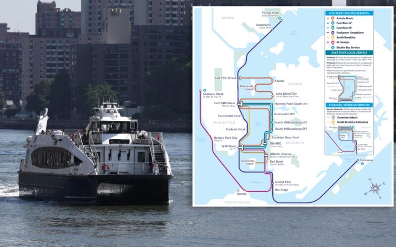
The new map will combine the Soundview and Rockaway routes, creating one uninterrupted ferry ride from Rockaway to Throgs Neck.
The St. George route, which currently connects Manhattan’s West Side to Staten Island, will now extend to Brooklyn and end its run at Wall St.
The new map shifts the southern Brooklyn route northward, adding a stop at the E. 34th St. landing in Midtown Manhattan, but taking away service to Sunset Park and Bay Ridge on that route. As a trial run, NYC Ferry will restore service to those two southernmost landings during summer weekends in 2026.
NYCEDC
NYC Ferry’s redesigned route map goes into effect December 8, 2025. (NYCEDC)
During peak travel times, the East River route will be split into two, effectively running skip-stop service up the Brooklyn and Queens side of the river. During midday on weekdays and on winter weekends, “local” ferries will serve all East River route stops.
In addition to the ferry service reroute, NYC Economic Development Corp. — which controls the ferry network and contracts out its operations — announced it plans to open two new ferry landings, one in East Harlem at 125th St. and another in Sunset Park near Pier 6, north of the neighborhood’s existing landing. EDC is also working to expand the E. 34th St. landing in Midtown.