


City and state transportation officials have more details on their plan for the Cross Bronx Expressway — one that includes caps over portions of the highway to reconnect neighborhoods separated by the Robert Moses-era roadway.
The plan, along with several other recommendations, was released Monday as part of a so-called “vision report,” the result of two years of community outreach and study funded by the feds.
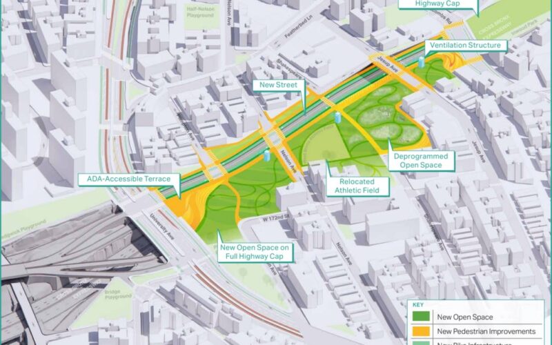
Caps involve building local streets, green spaces or other new features over the top of portions of the roadway that run below street level. The expressway has been called the most congested road in the United States.
The report lays out short-term, medium-term and long-term goals for a redesign of the notorious corridor, including several pedestrian-safety efforts in the surrounding neighborhoods that could be put into place as early as this year. But the report’s major takeaway is support for capping the highway along several below-grade stretches, reconnecting neighborhoods divided since the Cross Bronx Expressway’s construction in the middle of the 20th century.
“A disconnected and irregular street grid creates unique mobility and traffic safety challenges, and there are relatively few opportunities for people who travel by foot, bike, or transit to cross the highway,” the report reads. “Overflow highway traffic regularly spills onto local streets, placing additional health and traffic safety burdens on residents.”
The proposed caps — which, according to the report, could include green spaces as well as newly built local surface streets —are not feasible across all below-grade portions of the highway.
But the report proposes, among others, a continuous cap from University Ave. to Walton Ave. — effectively reconnecting Morris Heights and Highbridge — a cap over the highway near Arthur Ave., joining Crotona Park and Walter Gladwin Park, and a cap extending Hugh Grant Circle, which currently sits above the Cross Bronx.
“With this milestone, New York City takes a huge step towards improving quality of life for the communities that live along the Cross Bronx Expressway,” NYC DOT Commissioner Ydanis Rodriguez said in a statement.
State DOT Commissioner Marie Therese Dominguez, also in a statement, said the highway had cut “a deep hole in the heart of the Bronx.”
“The release of this visioning study represents the first important step in reclaiming the expressway for the borough and its people,” she said.
But Monday’s report is just that — a first step. Any significant changes to the Cross Bronx will require an environmental review, additional planning, and — crucially — funding.
“Long-term transformative project concepts, including potential highway caps, would require close collaboration and large amounts of city, state and federal funding to implement,” the report reads. “As these concepts advance, potential funding sources will be identified.”
Locals Call For Capping Cross-Bronx Expressway To Reduce Negative Health Effects
Spencer Platt/Getty Images Cars and trucks move along the Cross Bronx Expressway. (Photo by Spencer Platt/Getty Images)
One of the more controversial portions of the plan to rebuild the Cross Bronx — a so-called multimodal connector spanning the Bronx River that critics say amounts to a widening of the highway — is not mentioned in the report released Monday.
That effort is part of the work to rebuild the elevated sections of the highway. A City Department of Transportation spokeswoman told the Daily News that the connector is a separate project fully under the auspices of the state DOT.
A state DOT spokesman did not immediately reply to a request for comment, but previous reports indicate that the state is considering a bicycle-and-pedestrian path option for the connector.